Wednesday, December 30, 2009

Return to Peru: Brief Humanitarian Trip

We had the opportunity to return to Peru with Beverly's sister and her husband during the first two weeks of December 2009. It was a wonderful opportunity to gain closure after our abrupt departure from our mission at the end of August.

This is a picture of the Tarma valley. It shows the dirt roads we took up the mountain to the Yanamarca ruins:


The Palcamayo valley as viewed 3000 feet above on the cliffs of Yanamarca:


Beverly and Scott pose on the cliff by 1000-year-old, pre-Inca ruins of Yanamarca:


We had the great blessing of seeing many of our dearest Peruvian friends. Our closest friends were the Durmand family shown here--Karola, Alex, Durman, and Cami:


Other dear friends bid us farewell at our Tarma hotel--Mayra Quinto, José Quinto, Sharon (granddaughter of José), Beverly, Martha (wife of José), Scott, Caroli Leyva, Sister Leyva (no relation to our former mission president), Sister Chuco, and Ángel Chuco:


After visiting our former missionary area of Tarma, we traveled to Tarapoto, in the high Peruvian jungle on the eastern slopes of the Andes. There we worked with the Rotary International Club of Tarapoto to inspect and initiate a water-conservation and reforestation project:


From Tarapoto, we flew to Iquitos in the low Peruvian jungle of the Amazon basin. This is a hut on the banks of the mighty Amazon River:


We stayed in a rustic lodge in the jungle:


We inspected three fish-farm projects sponsored by Rotary International and the Hope Alliance of Salt Lake City. This fish farm was located just outside the village of Yanayaco in the dense jungle:


Two other Hope Alliance fish farms were located near the jungle village of Las Palmas. This is a member of the village:


Four Las Palmas boys, ages 10-13, walked with Scott into the jungle to inspect the fish farms :


Hope Alliance also sponsors micro-credit loans in Iquitos. This woman received a loan to begin her sewing shop, where she sews shirts, dresses, and sports clothing:


Boathouses on a river that passes through Iquitos:


A houseboat in Belén, a suburb of Iquitos:


Houses on stilts along the river in Belén:


We loved our return to the Peru Lima East Mission and our visit to a new part of Peru, the jungle cities of Tarapoto and Iquitos. It was a magnificent trip.

Tuesday, December 29, 2009

Update: 8 Natural Regions of Peru

Peru has eight natural (or geographical) regions, and all eight regions are represented in the Peru Lima East Mission. Below you can see Scott's photos of each region, the first six photos were taken during our mission and the last two during a December 2009 return visit to Peru.

Chala region is the coastal area along the Pacific Ocean. It is subtropical dry and tropical savana. Lima (where we lived for 4 months) is in the Chala region:


Yungas region has an altitude of 1,600 to 5,000 feet above sea level. It includes the forest along the eastern slopes of the Andes mountains, with an extremely diverse climate, flora, and fauna. We traveled through this region during our trips from Lima to Tarma:


Quechua region, altitude 7,500 to 11,500 feet, includes big valleys divided by rivers. The second largest city in our mission, Huancayo, is in this region. Cusco and Machu Picchu (not in our mission) are also in this reagion. We lived in Tarma, which is also part of this region:


Suni region, 11,500 to 13,500 feet, is dry and cold. Cities in our mission in this region and that we have visited, include La Oroya (where we went most Saturdays while living in Tarma), Huancavelica, San Pedro de Cajas, and others. This picture shows the Suni region near the town of San Pedro de Cajas:


Puna region, 10,500 feet to 14,800 feet, includes the altiplanos or pampas (vast high plains), where puna grass grows. The two cities in our mission in the Puna region are Cerro de Pasco and Junín (where we went most Saturdays). This picture shows the Puna region, with wild vicuña, between San Pedro de Cajas and Junín.


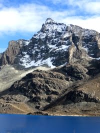
Junca region includes the jagged, snow-covered mountains above 13,500 feet. This picture was taken near Ticlio, the mountain pass (at 15,800 feet) that we traveled through in going from Lima to Tarma:


Rupa region, 1,600 to 2,300 feet, is the high jungle areas on the eastern side of the Andes Mountains. The city of La Merced in our mission (and where we attended a Multi-zone Conference) is located in the Rupa region. This picture was taken after our mission when we visited Tarapoto:


Omagua region is the low (below 1300 feet) jungle. The town of Satipo in our mission is located in the Omagua region. We visited Iquitos, on the Amazon River, after our mission, and Scott took this picture when we visited the Amazon jungle.


The Peru Lima East Mission is an extremely geographically diverse mission, with probably the biggest elevation changes of any mission in the world.

Friday, October 23, 2009

Scenes of the Peru Lima East Mission

The following pictures, taken by Elder Scott Zimmerman, provide a brief pictorial overview of the Peru Lima East Mission. To see an enlarged view of any pictures, just click it; and then click the Back arrow button on your browser to return to the blog.

The Peru Lima East Mission includes not only the mission office but also the South American Northwest Area Offices:


The Lima Missionary Training Center (Lima MTC) [also called the "Centro de Capacitación Misional" or CCM] is also located within the boundries of our mission:


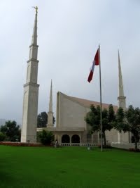
Near the Lima MTC and within our mission is the Lima Temple:


Lima has large shopping malls and department stores, but it also has open-air markets:


The Pacific Ocean forms the western border of Peru, although the beach is not in our mission:


A view of the Pacific at sundown:


The mission also includes the High Central Peruvian Andes. This picture shows the terraced farmlands on the south side of the city of Tarma, shown down at the bottom of the valley:


Two women load milk to take to the local market in Tarma:


The dirt road that winds its way up the mountain between Palcamayo and San Pedro de Cajas:


An LDS member of the San Pedro de Cajas (13,300 feet above sea level) branch:


An LDS member of the Junín branch (13,600 feet):


A wild vicuña, relative to the domesticated llama and alpaca:


An open-air market in Izcuchaca, Peru, between Huancayo and Huancavelica:


Farmlands built on the edge of cliffs in the High Central Andes near Huancavelica:


A common site throughout Peru: Catholic chapels. This one is located in Huancavelica.


A Quechua-speaking member of the Huancavelica branch:


High mountains and meadow (13,500 feet) with a shepherd and his dog:


Lake Junín, the second largest lake in Peru (Lake Titicaca is bigger), located at 13,500 above sea level, in the cold, wind-swept Pampas (altiplano) of Junín:


An 18,000-foot peak near Ticlio pass:


To see more of Scott's pictures of Peru and the Peru Lima East Mission, click here.

Peru Lima East Mission (Misión Perú Lima Este)

The Peru Lima East Mission (Misión Perú Lima Este), from which we recently returned home, covers the east side of the city of Lima (on the coast) and also the High Central Andes of Peru.

The mission is one of seven missions (as of October 2009) in Peru, as shown in this map:

The Peru Lima East Mission, the Peru Lima North Mission, the Peru Lima South Mission, and the Peru Lima Central Mission, each cover a section of Lima as well as several regions (state-like politcal areas), as indicated in the above map.

The Peru Lima East Mission includes the following regions: Lima, Huánuco (with the city of Huánuco as its capital), Pasco (with Cerro de Pasco as its capital), Junín (with Huancayo as its capital and includes Tarma where we lived for seven months), and Huancavelica (with the city of Huancavelica as its capital).


To travel through the Peru Lima East Mission involves more elevation changes that any other mission in the Church. A typical tour of the mission starts in Lima (sea level, where there are 10 LDS stakes), goes up from there over Ticlio pass at 15,807 feet above sea level, drops down to La Oroya (12,200 feet; 2 LDS branches), passed through the town of Junín (13,600 feet; an LDS branch), climbs up to Cerro de Pasco (14,200 feet, the highest stake in the Church), drops down to Huánuco (6,200 feet; two stakes), returns past Cerro de Pasco, drops down to Tarma (10,050 feet; four LDS branches), drops farther down to La Merced (2,600 feet; an LDS stake), returns up to Tarma, goes over a pass of 13,600 feet, drops down to Huancayo (10,600 feet; two LDS stakes), travels on to Huancavelica (12,100 feet; an LDS branch), and returns over the Ticlio pass and back down to Lima.

For more information about this fabulously diverse mission, read more of this blog.

Wednesday, September 9, 2009

Death of Our Daughter; End of our Mission

It is with heavy hearts that we inform you of the passing of our daughter Sheri Lynne Zimmerman Klein (age 33), on Sunday, August 30, 2009, due to complications (eclampsia) from childbirth. Her newborn (second) daughter Ava Lily Klein was taken by C-section and is healthy and strong. Sheri's first daughter Abbey, age 3, and husband Eric are doing as well as could be expected.

We were released from our mission by the mission and Area presidents. We left Tarma on Tuesday, September 1, and flew out of Lima that night, arriving at our home in Orem on Wednesday. On Thursday, we attended a memorial service for Sheri in Lolo, Montana, where she was living at the time of her passing. We held a viewing on Friday in Orem and her funeral and burial on Saturday.

Picture of Abbey, Sheri, and Eric, taken July 2008:


Thanks to all of you who followed our blog during our 11 months as missionaries. We will of course miss our daughter but we will also miss the wonderful people of our mission and the many friends we left behind in the High Central Andes of Peru.

Monday, September 7, 2009

What Tourists See in Peru

Our mission president and the Area presidency gave us permission to travel around Peru with Scott's sister and her husband. We saw many amazing places and people. Thousands of tourists visit Peru every year. If you were to visit Peru, what might you see?

You might visit the Cathedral in the Plaza de Armas (central square) of Lima:


... where you would see statues of Mary with her robe in the shape of a mountain--a ploy the Spaniards used to convince the Inca people to worship Mary as they did the mountain Gods:


You might visit the San Francisco chapel, with its catacombs in the basement:


Not far south of Lima is the archaeological site of Pachacamac:


You might visit the museums in Lima filled with wonderful examples of pre-Inca and Inca pottery:


Or you might travel 3-4 hours south of Lima to see the Ballestas Islands and the National Preserve at Paracas with wildlife of many types:


On one of the Ballestas Islands you could see the huge "candelabra" drawing. To us it looked like a "Tree of Life":


You could take a plane ride over the mysterious Nazca Lines, enormous drawings in the desert rock. The lines can only be seen from the air:


Most tourists travel to Cusco. Here two young women pose in the ceremonial costume of Cusco:


On a hill overlooking Cusco, you could visit the mammoth archaeological site of Saksawaman:


You could see women wearing their traditional hats and sweaters selling produce and souvenirs:


An amazing Inca site you could visit is found at Pisaq:


Here, a saleswoman and her daughter pose above the Pisaq terraces:


On the way to Machu Picchu, you could stop at the ancient Inca site of Ollantaytambo:


And of course, most tourists visit this Wonder of the World, Machu Picchu:


Machu Picchu is on the edge of the Peruvian jungle on a high mountain top:


On the train back from Machu Picchu to Ollantaytambo, you might be entertained by Peruvians in native masks and costumes:


You would probably want to visit Lake Titicaca. We stopped at various tourist sites, including this one, where Peruvian women sold their wares:


Some interesting Inca ruins are found at Raqchi:


You might get a close-up view of llama, alpaca (shown here), and vicuña:


Once in Puno, on the shore of Lake Titicaca, it's a short boat ride out to the floating islands of Los Uros. The islands, homes, and boats are made of reeds, which grow in the shallow western bay of the lake:


The Uros travel from their islands and to the mainland in small rowboats:


... but they also travel in reed boats:


Not far from Puno are the ruins at Sillustani, a pre-Inca and Inca burial site, with stones of granite (light colored) and basalt (dark colored):


A woman who lives near Sillustani posed for Scott:


Such are the amazing scenes and peoples you might see if you were a tourist visiting Peru.